
Cases
Citizens' city
XR technologies to extend participation in urban planning
Published:
By utilising XR technologies, Augmented Urbans project aims to improve stakeholder participation and linkage between long-term visions and short-term actions in the cities. One of the ultimate goals is to enhance urban resilience.
“Helsinki region hosts world-class expertise in both new digital technologies and urban participation. We are combining these two aspects in collaboration with our Central Baltic partners in the Augmented Urbans project”, describes Päivi Keränen, the project manager of the joint interregional initiative.
In urban planning, we are dealing with a radically different timescale than in our daily lives. The planning processes are long, and their results and implications are seen and experienced only after years and even decades. This makes it challenging for an ordinary citizen—or even an expert outside the sphere of urban planning—to participate and contribute in them. Simultaneously, urban environments face increasingly complex challenges. Tackling wicked problems, such as how to mitigate the negative effects of climate change, require inclusion of more diverse knowledge and expertise than ever before.
A design-oriented approach builds a wider understanding of the XR technologies
With a design-oriented approach and close collaboration with the Helsinki XR Center, Augmented Urbans brings city planners and XR developers together to build a joint understanding of the possibilities of these new technologies in urban planning. With project team consisting of urban and regional planners, architects, researchers, designers, and XR specialists, the project seeks to develop tools for participatory planning.
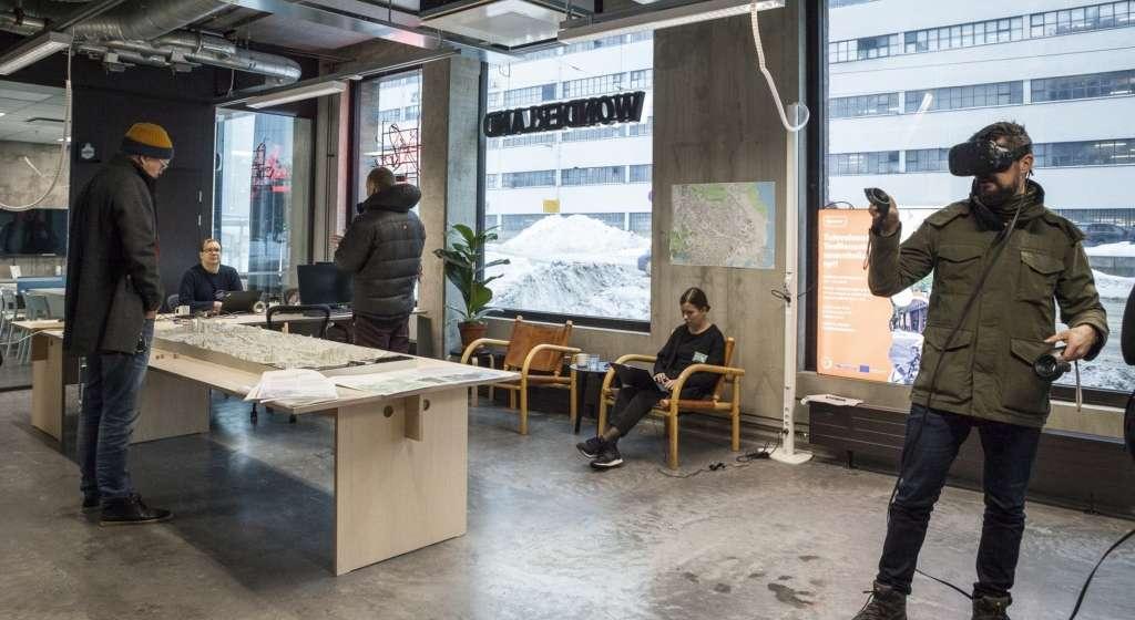
In Helsinki, the practical implementation focuses on the on-going process to create the outline plan for Teollisuuskatu area between two significant and growing commercial and transportation hubs, Kalasatama and Pasila. Developing the joint vision for the area calls for insights from property owners, entrepreneurs, cultural actors, NGOs, nearby residents and those working in the area, as well as from various experts. In this context, the viability of XR tools is tested for communicating planning principles, and collecting user information, suggestions and insights.
The three-year project will result in five social-ecologically integrated urban plans produced in collaboration with local stakeholders in Helsinki, Tallinn and Viimsi in Estonia, Gävle in Sweden as well as Cesis in Latvia. New augmented, virtual and mixed reality technologies (AR, VR & MR) are explored and utilised as tools that support urban planning processes by guiding discussions and providing immersive scenarios.
Image credit Tiia Ettala / City of Helsinki
For further information, please contact:
Päivi Keränen
Project manager
+358 40 184 1952
paivi.keranen@metropolia.fi
Jalmari Sarla
Communication Manager
+358 40 620 6366
jalmari.sarla@metropolia.fi


Recommended articles
For further information, please contact:
Päivi Keränen
Project manager
+358 40 184 1952
paivi.keranen@metropolia.fi
Jalmari Sarla
Communication Manager
+358 40 620 6366
jalmari.sarla@metropolia.fi